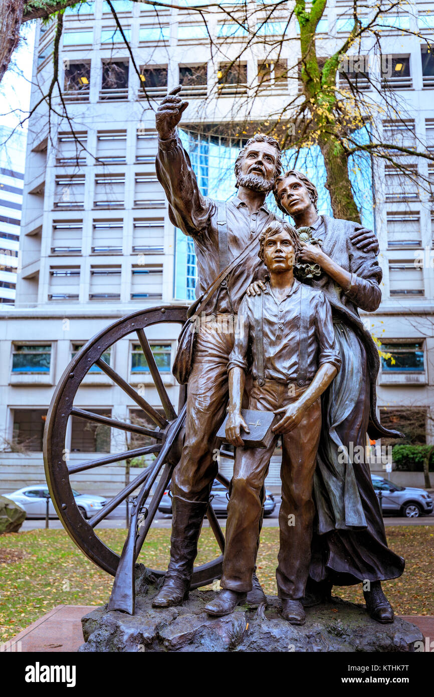
In Portland's Chapman Square is a bronze statue commissioned by the Oregon Trail Coordinating Council to commemorate the 150th anniversary of the Oregon Trail in 1993. The Promised Land, by Oregon artist David Manuel, depicts a pioneer family - father, mother, and son - at the end of their journey. The red granite slab upon which the statue is mounted is inscribed with a quote by Thomas Jefferson. Notice that there are three emigrants shown, a man, a woman and a young man, suggesting a family. A fourth member of the family is implied by the doll clasped to the breast of the sad faced woman in the statue. As mentioned, one in four died on the river. As you migbt guess, the Oregon Trail and Portland's Sandy Boulevard are closely linked in our history.
___________________
Sandy Boulevard runs 14 miles from Southeast Seventh and Washington to its abrupt end at N.E 247th. Why? Sandy doesn't seem to start anywhere for any particular reason nor end anywhere for any particular reason. At one end is a storage lot for recreational vehicles and a private home surrounding a traffic turn-around. And at the other end, at 7th & S.E. Washington, there's a mixed commercial residential neighborhood, but not much of interest. So why?
There are two puzzles here:
First, since Roman times it’s been standard practice, at least in the West, that streets and avenues run more or less north and south or east and west. Roads running at angles across north-south or east-west are not unknown, but they are unusual, built meet a specific travel need.
Second, roads take time to plan and engineer and hard work to construct. Roads are expensive to build. People don’t suddenly get random urges to slap a road across the landscape on a whim. The basic fact of all roads is that they start where people are and go to where people want to be.
But Sandy starts nowhere and ends nowhere.
At least today.
And that's the clue. What was going on when Sandy Boulevard was first traveled? There's history involved, but fear not. It's important history of Oregon and the city of Portland.
Between 1818 and 1846, all of today's Oregon, Washington and Idaho was a shared territory governed in practical terms by the British Hudson’s Bay Company. Even though we had a Joint Occupancy Agreement with the Brits, most of the people living here were British, French Canadian with a few ex-patriot American fur trappers such as Joseph Meek and thousands of Native Americans. Despite the Chinook, Clatsop, Tualatin, Cayapoia, Shoshone and myriad other Indians inhabiting the Pacific Northwest, this was British controlled territory. And the last thing the British wanted were a bunch of American “Emigrants” squatting on what they claimed as Crown Property.
Once Americans started arriving in 1839 in the upper Willamette Valley over the Oregon Trail, we know from the historical record that the McLoughlin Road was the route Americans were forced to take between Fort Vancouver and Oregon City – because the British did not want Americans settling in their territory. But, they had no way of getting rid of us. It wasn’t exactly easy to deport us back then. We’d have had to walk the twenty-one hundred miles back to the United States.
The first emigrants to arrive in Oregon got here by walking the two thousand miles from Missouri to Oregon across the “Great American Desert” starting in late April and arriving in The Dalles in late September or early October.
Between the 1803 Lewis and Clark Expedition and the year of the first true wagon trains on the Oregon Trail in 1843, a few hardy souls crossed, mostly missionaries such as Jason Lee and the Whitmans. The first year of migration on the Oregon Trail was 1839 when perhaps thirty people made it across country carrying their belongings on their backs. A year later Joseph Meek managed to get wagons from Idaho in to the Willamette Valley. In 1840 a slightly larger group made it. In 1841 seventy hardy souls. A few more in 1842.
Then in 1843, known as the year of the Big Migration, over 1,000 men, women and children (many the children and grandchildren of Daniel Boone) walked alongside their prairie schooner wagon and oxen every step of the way to Oregon from Missouri.
The 1843 party departed Elm Grove, Missouri, on May 22, and arrived in a small encampment, The Dalles, on the Columbia River at the east entrance of the Gorge in October. (Native American men, women and children lived in The Dallas for at least 10,000 years.)
At The Dalles emigrants found their way into the Willamette Valley blocked by Mount Hood and the surrounding Cascade Mountains. Their only choice to was to raft the rapids of the Columbia River – there was no other choice.
The Columbia Gorge is an eighty-mile long gash in the Cascade Mountains between Mount Hood to the south and Mount Adams and St. Helens to the north, with walls in places towering four thousand feet over river level. In The Dalles emigrants cut or purchased logs from the Native Americans who lived in the area, took the wheels off their wagons, and lashed wagon and all onto a rough raft of 18 foot long thirty inch diameter logs. Despite the size of the raft, emigrants stood ankle deep in freezing water atop the logs for the days and weeks it took them to travel the eighty miles.
Remember now, the emigrants had just spent five months walking from Missouri. Their animals were exhausted, and so were the emigrants. Many were out of supplies – the bacon, flour and coffee that fueled their travel. And because of this diet, many had developed the symptoms of scurvy, a disease caused by a lack of Vitamin C in their diet.
This trip down the Columbia was their last long test of endurance. It was October or early November and they had to get through to the Willamette River before the snows started. And the trip down the Columbia that we drive in an afternoon took as long as a month.
The Columbia River Gorge was not just the last but the most dangerous and difficult leg of their journey. Poling their rafts on the river, emigrants struggled to keep control and above the rough water until they reached the three impassable rapids near today's Cascade Locks, where a mile-wide river was compressed into a 450 foot wide spout that dropped twenty feet in less than a mile, the worst rapids of a wild untamed river.
There was no way experienced canoeists would try these rapids. Neither would the professional watermen, the "vouyageurs" of the Hudson's Bay Company try to take their bateaux down the Cascades. Farmers from the Midwest had no choice but to portage around. It was a brutal experience in the cold, snow and ice, taking the wagon and their remaining possessions off the raft, transporting heavy water-soaked logs around the portage as well, then rebuilding the raft, reassembling and loading the wagon, hitching up your surviving oxen and dragging it all around the rapids, then tearing down your wagon, reassembling your raft, then finishing your 180 day trip to Oregon at the mouth of the Sandy River.
And if you didn't get your raft to the shore just above the Cascades? Your chances of survival were slim to none.
Once out of the gorge, a few emigrants would continue downriver to Fort Vancouver – where they would be directed to cross to the south bank, reassemble their wagons, and take the road south to Oregon City.
 |
| Courtesy of the Oregon Historical Society |
But look at the road on the map angling from roughly Portland east to the Columbia next to the Roman numeral III. It starts on the south bank of the Columbia at the mouth of the Sandy River, then travels west south west across the heavily forested Willamette Valley until it connects with the McLoughlin Road, approximately at today’s S.E. Seventh and Washington and across from the 1852 village of Portland. Right where today’s Sandy Boulevard starts on its route East.
* * * * *
"Oregon Trail emigrants arrived at the Sandy River after descending the Columbia or traveling its rugged banks with livestock. Emigrants camped along the banks of the Sandy River reassembling wagons and recuperating. Crossing the Sandy downstream from this site, and climbing the hill behind the Harlow House, where the trail is still visible, emigrants could look behind at the bluffs that today mark the western entrance of the Columbia Gorge. For emigrants, however, these bluffs marked the eastern gateway to the Willamette Valley."
- Sign at the Harlow House Museum in Troutdale
* * * * *
Conclusion: Today's Sandy Boulevard was the Sandy Road, the original end of the Oregon Trail, built at least three years before the Barlow Road around Mount Hood created a torturous all-land route into the Valley. Many historians state that more emigrants continued to use the Columbia River route because of the hazards and expense of the Barlow Road.Between 1841 and 1860 when steamboat service above and below the Cascades and a portage railway around the rapids started carrying emigrants, our humble, much-maligned Sandy Boulevard was the primary route for thousands of immigrants coming into the valley, as they came out of the Columbia at the mouth of the Sandy River, reassembled their wagons, briefly mourned those who died in the river before setting off on their last two day trip to Oregon City and the end of the Oregon Trail.
Comments
Post a Comment